Evelyn and I loved to travel to Latin America which in our case was represented by Central and South America. That is, it excluded Brazil, and why? Mainly because we felt most at easy in Spanish speaking America, although Evelyn could have navigated the Portuguese language.
We gravitated towards two South American destinations: Ecuador and Chile. The former, because of obvious reasons, I had deep roots in it that are described in detail in my autobiography. Chile, principally because of its spectacular nature. We also visited Perú, once.
Our Central American target was, specifically, winter vacationing in Costa Rica.
My first South American experience was a passage during my family’s WWII departure from Europe in 1942. That adventure is described in detail in my autobiography and I will not dwell on it here any further. It had mainly involved Argentina and Chile, as well as our weeks long shipboard travel from Spain to Ecuador.
Our first conjugal trip was to Ecuador as part of our honeymoon travels in May-June of 1960. That visit was mainly centered on Quito to introduce Evelyn to my parents. We took some short excursions outside the capital to Tingo (thermal baths), the equatorial marker and to the Otavalo market.
1983: Chile and Ecuador
Our first major trip to the southern hemisphere was motivated professionally. I was invited to give a short but intensive course on aerosol measurements at the physics department of the University of Santiago in Chile, in 1983, invited by physics Prof. Alex Trier of that institution. We were housed in an apartment of the University.
It was during that stay that we established our years long friendship with Carlos and Marcela Vial, whose firm in Santiago represented GCA in Chile. Carlos was of the old Spanish stock, perhaps going back to Visigothic “sangre pura”. Marcela appeared “mestiza”. He embraced Pinochetism. I tried to abstain from politics during our conversations. Contrastingly, we were invited to dinner at Prof. Trier’s home were we met his family. They were Allendistas, and his sons were decidedly anti-American, thanks to the notorious intervention of the CIA in Allende’s suicide/assassination and Pinochet’s takeover in 1973.
Marcela Vial drove us, south of Valparaíso, to Casa de Isla Negra to visit the idiosyncratic house that had been owned by Pablo Neruda there.
Following our Chile stay we travelled to Ecuador. My childhood friend Ovidio Wappenstein had made arrangements for us to stay at an apartment belonging to his father-in-law Hugo Deller. We met Ovidio’s wife, Betty, whom I had known, for the first time as a small girl, in 1943, at her father’s hacienda, and then again during our honeymoon in 1960.
We went on excursions with Ovidio and Betty to Otavalo and surrounding areas, as well as to the foot of the Cotopaxi volcano.
Eventually, we rented a car, a small 4-wheel drive, underpowered vehicle, and travelled to Baños where we stayed for one night after hiking in the nearby hills. From there we continued to Tena at the eastern foothills of the Andes where we overnighted at a rundown hotel where the administrator was a multifunction individual: he washed our mud-encrusted car, transported our bags to our room, managed the dining room, cooked and served the dinner, clerked the reception and cashed our payment.
The only other customers in the dining room were a quaint youngish couple of Americans, missionaries on their “night out”.
We then continued on the only then existing road on the eastern slope of the Andes, stopping for breakfast in the town of Baeza before turning west to surmount the cordillera on a muddy road where we narrowly avoided a careening truck descending and sliding at breakneck speed. In a few miles we went from an altitude of about 6,000 ft. to 13,500 ft., from warm subtropics to a snow storm, before descending towards Quito.
Helped by Ovidio we were able to secure a last minute reservation on a four-day cruise around the Galápagos islands which we thoroughly enjoyed. It exposed us to the pristine life on the islands where the behavior of the animals betrayed an absolute and striking fearlessness towards humans. We struck up an onboard friendship with a Spanish couple from Galicia whom we met again, years later in 2004, in Santiago de Compostela, in Spain. We then returned home from Guayaquil.
1996: Chile
Evelyn had identified a rather unique trip combination to southern Chile: a cruise through the strait of Magellan and the Beagle channel followed by a stay at a recently created ecological lodge called Explora, within the Torres del Paine national park in Chilean Patagonia.
We thus flew to Santiago from where we continued southward on a LAN Chile plane, with a stop at Puerto Montt, then to Punta Arenas on the strait of Magellan, the last, a four-hour flight. There, we boarded a small (90 passengers) Chilean cruise ship, Terra Australis, which then took us, through convoluted passage ways, surrounded by magnificent glaciers, to the famous Beagle channel, south of Tierra del Fuego. That channel was named after the ship on which Darwin travelled around the world from 1831 to 1836.
We disembarked at Ushuaia on the Argentinian side of Tierra del Fuego, and then at Puerto Williams and Puerto Toro both on the island of Navarino on the Chilean southern shore of the Beagle channel. The latter stop was a small outpost with a few dozen inhabitants, mainly descendants of the indigenous population of this remote region. It is the most southern town of South America.
During these stops we went on several excursions. On one of them we had to cross a mountain brook where both Evelyn and I lost our footing, filling our hiking boots with water. On returning to our ship the crew resolved our mishap, stuffing newspapers into our boots, a very effective drying solution.
On our return to Punta Arenas we stopped at Magdalena island in the strait of Magellan and walked through a colony of thousands of Magellanic penguins, a very special experience.
From the Punta Arenas dock we were picked up by a van and taken on a five-hour northward drive to Explora Salto Chico lodge in the midst of the Torres del Paine national park. On the way we stopped at the Cueva del Milodón where there is a statue of the giant sloth, now extinct, that had inhabited in that region. We stayed at Explora for five days during which we went on several guided hikes in that stunning Torres del Paine park. Eventually we returned to Punta Arenas, flew back to Santiago where we stayed with the Vials for a few days before going home.
2007: Ecuador and Peru
We flew to Quito where we were picked up from the airport by my friend Gustavo Fierro and taken to Patio Andaluz, a delightful boutique hotel less than two blocks from the main square, Plaza de la Independencia, also known as Plaza Grande in colonial times.
We had several emotional reunions with some of my erstwhile Politécnica classmates as well as a visit with Gustavo Fierro to Ovidio Wappenstein’s country villa about a dozen miles from Quito in Cumbayá where Betty, Ovidio’s wife had prepared an outdoor lunch for us. Ovidio was showing some evidence of diminished mental acuity which would aggravate in subsequent years. In the past he had been a very dynamic and extroverted person but now exhibited a noticeable placidity.
After spending a few days in Quito, we rented a car and travelled northward along the Pan-American highway. Our destination was Hacienda Zuleta, a beautifully located country estate belonging to the Plaza family (two of its members had been presidents of Ecuador).
On arrival at Zuleta we were greeted by a German couple who were administering the property and who informed us that we were the first foreign visitors ever arriving there by themselves, i.e., without an Ecuadorian driver or guide. It had been a bit challenging for us to locate the inn by traveling on small unmarked country roads. Our Spanish language proficiency had been most helpful.
We met a member of the Plaza family who showed us around the property, delighted to interact in his native language. We were the only guests during our stay at Zuleta.
We took a hike in the nearby mountainous area with a guide provided by Zuleta from where we had a striking view of the nearby 19,000-ft Cayambe volcano. During the return trek we were regaled with a rare sighting: a spectacled bear scrambling along a steep mountain side, the only South American bear, found almost exclusively in the Andes mountains.
From Zuleta, north of Quito, we then travelled south skirting the city and passing through Sangolquí, a suburb of the capital. It proved to be another challenge because of ill-marked detours caused by extensive construction projects. Again, our Spanish language proficiency proved invaluable. Eventually we rejoined the Pan-American highway, south of Quito, until reaching an exit and a country road that took us to another country inn: San Agustín de Callo, a remarkable hacienda which also belongs to the Plaza family. It is located only a few miles from the beautiful Cotopaxi volcano (19,347 ft.), second highest summit in Ecuador (after Chimborazo) and among the highest active volcanoes in the world.
San Agustín de Callo is rather unique in various ways. First of all it incorporates, or is built around, the ruins of the northernmost remaining Inca building in South America. Secondly, it was visited by two important scientific missions over the last 300 years: the French Geodesic Mission that arrived there in the 1730s to measure the curvature of the Earth near the equator, and the sojourn by Alexander Humboldt in 1802. In addition, in 1859 Frederic Church, notable naturalist painter of the Hudson river school of art, stayed there when he painted the nearby Cotopaxi mountain.
We stayed in the “geodesic room” where members of the 18th century French mission had spent several nights.
The walls of the dining room of the hacienda are entirely constituted by the the remarkably fused granite blocks, remaining from the original Inca 15th century palace.
During our two-day stay at San Agustín we were driven to the slopes of the Cotopaxi volcano and hiked up part way towards the refuge near the lower edge of the summit glacier. We were beaten back by deteriorating weather: wind driven hail.
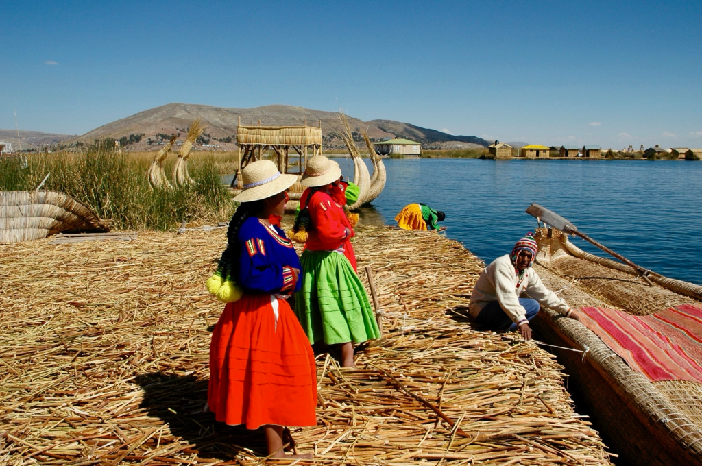
After or stay at San Agustín, we drove to Quito’s airport and flew to Lima, Perú, where we spent the night at the Country Club Hotel, a very pleasant boutique hotel on the outskirts of the city. The next morning we flew from Lima to Juliaca from where we were driven to Puno, to hotel Libertador Esteves on the shores of Lake Titicaca whose surface is at an altitude of 12,500 feet. The next morning, we boarded a launch on the lake, that took us first to the unique floating Uros islands (see photo below).
Note: All photos shown in this travelogue essay were taken by me.
These islands as well as the boats are built from floating sedge.
I am including here a description taken from the Wikipedia entry “Lake Titicaca”:
“The “Floating Islands” are small, human-made islands constructed by the Uros (or Uru) people from layers of cut totora, a thick, buoyant sedge that grows abundantly in the shallows of Lake Titicaca. The Uros harvest the sedges that naturally grow on the lake’s banks to make the islands by continuously adding sedges to the surface.
According to legend, the Uru people originated in the Amazon and migrated to the area of Lake Titicaca in the pre-Columbian era, where they were oppressed by the local population and were unable to secure land of their own. They built the sedge islands, which could be moved into deep water or to different parts of the lake, as necessary, for greater safety from their hostile neighbors on land.
Golden in color, many of the islands measure about 15 by 15 m (50 by 50 ft), and the largest are roughly half the size of a football field. Each island contains several thatched houses, typically belonging to members of a single extended family. Some of the islands have watchtowers and other buildings, also constructed of sedges.
Historically, most of the Uros islands were located near the middle of the lake, about 14 km (9 mi) from the shore; however, in 1986, after a major storm devastated the islands, many Uros rebuilt closer to shore. As of 2011, about 1,200 Uros lived on an archipelago of 60 artificial islands, clustering in the western corner of the lake near Puno, Titicaca’s major Peruvian port town. The islands have become one of Peru’s tourist attractions, allowing the Uros to supplement their hunting and fishing by conveying visitors to the islands by motorboat and selling handicrafts”.
From the Uros islands we continued by boat to Taquile island where we hiked up to its main village at about 13,000 ft. We noticed that both on Uros and Taquile the local indigenous population had unusually dark skin complexions, presumably an evolutionary adaptation to the prevailing high intensity of ultraviolet light (below, two children on Taquile island).

After Taquile island we proceeded across the lake to our next destination: Suasi, a small island in the remote northeast area of the lake. Suasi is a private island with a beautiful small ecologically minded hotel. Suasi is home to the four South American camelids, alpacas, llamas, guanacos and vicuñas. We hiked around this delightful island enjoying the magnificent views of the surrounding lake Titicaca.
After a two-day stay on Suasi island we were take taken to the nearby land from where we were picked up with a van on a long drive northwest on the altiplano to Cusco. That trek took us over an Andean pass at about 15,000 ft. altitude. On the way to Cusco we stopped at a series of interesting Inca ruins and quaint villages. We also witnessed the roadside presence of dogs which we were told congregate to catch food that truckers throw to them as they pass by.
Near and above Cusco we visited the remarkable sprawling ruins of the Sacayhuaman citadel at 12,140 ft. Its walls are of an astounding size raising the question of how they could have been erected.
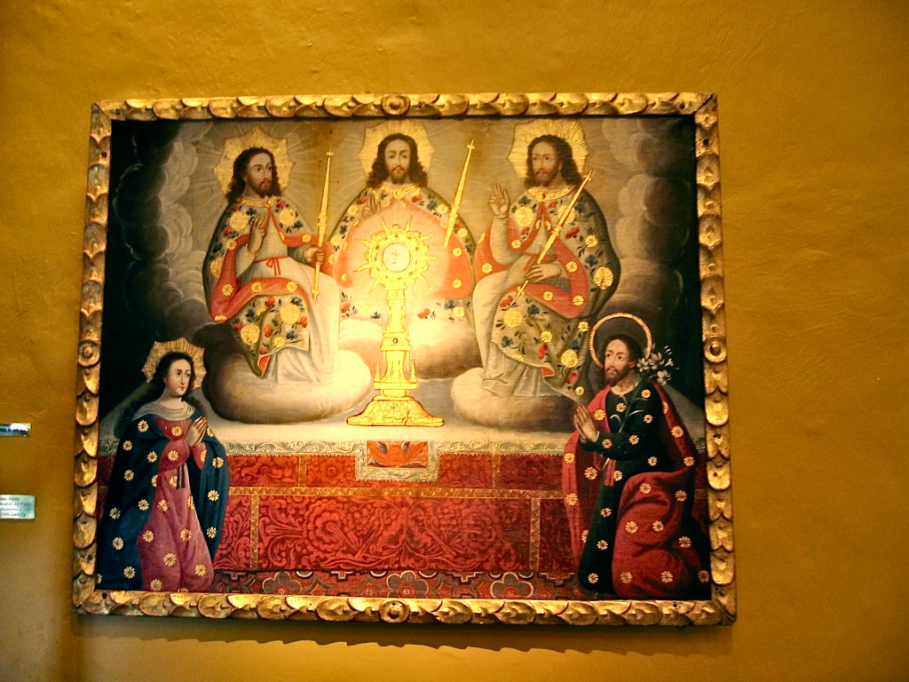
In Cusco we stayed at the hotel Monasterio which is a Baroque seminary built in the 17th century on Inca foundations. It is an iconic building with beautiful courtyards and well appointed rooms which feature oxygen feeds to help non-altitude acclimated guests. We did not require such respiratory support as we had spent time at high altitude on lake Titicaca. The corridors of the hotel Monasterio are hung with numerous religious art works of the Cusco School of painting of the colonial era. The, to me, most curious example of that collection was a 16th century depiction of the Trinity represented by three figures of Christ (see photo below). We were also taken on a visit of Coricancha, the Temple of the Sun in central Cusco. This city had been the capital of the Tahuantinsuyo, the Inca Empire which had extended over the present countries of Perú, Ecuador, Bolivia, and parts of Colombia, Chile and Argentina.
We spent only one night in Cusco at this point; we were to go back to that city a few days later on our return from the Urubamba Valley, also called the Sacred Valley, and Machu Picchu.
On our drive (with our guide and a driver) to the Sacred Valley, we stopped at a weaving center where numerous llamas, alpacas and vicuñas were milling around. We then continued and were served a field lunch on the way, prepared by our guide. It eventually proved to be a big mistake: we later were attacked by a digestive upset which affected me much more than Evelyn.
We were driven to Pisac, a remarkable complex of Inca ruins of a citadel on precipitous slopes. There we hiked up and down on precarious paths with magnificent views. Our female guide judged us fully capable to negotiate those rather daunting and dangerous tracks.
We then proceeded to Moray, a site with notable terracing, from which we then hiked to the remarkable Maras salt pans surrounded by mountains. It was here where I started to feel quite ill having to walk very narrow paths separating the salt pans. Eventually we reached the Huayocari hacienda where we were expected to be served lunch. I, however, was unable to eat. We continued to our next overnight stop, Sol y Luna, a beautifully landscaped property with small bungalows where I collapsed into bed while Evelyn, less affected by the stomach bug, was able to dine.
The next morning we were driven to the village of Ollantaytambo, surrounded by more Inca ruins. It marks the end of the Sacred valley where we boarded the train towards Aguas Calientes at the foot of Machu Picchu. The train tracks parallel the Urubamba river in a narrow gorge that gradually descends from Ollantaytambo at 9300 ft. to 6800 ft. at Aguas Calientes. As the train proceeds, the vegetation becomes ever more tropical, eventually even jungle-like.
Aguas Calientes is the end station of this train. The town is remarkably unattractive, a tourist trap of endless vendor stands with cheap paraphernalia. There, we boarded a small bus that took us on a steep winding road up to the citadel of Machu Picchu at just over 8000 ft. The bus reached the end of this meandering road in front of our hotel, the Sanctuary Lodge (now called Belmond Sanctuary Lodge which presently charges over $2,000 a night). The hotel is ideally located, adjacent to the entrance gate of the Machu Picchu citadel.
We stayed at Machu Picchu for two nights. It is a challenge to give an adequate descriptive justice to the site. It is unique because of its combination of remarkably well preserved Inca stone structures and its astounding siting (see photo below). Having been exposed during this trip to many remnants of Inca architecture, I came to the conclusion that they were the masters of mountainous building. I like to label it an astounding vertical culture.
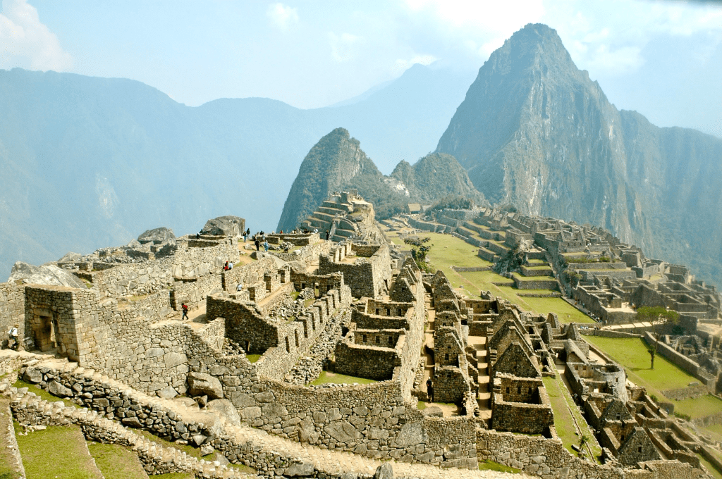
We scrambled up and down the multiple levels of the citadel. Its thorough exploration requires stamina. What adds to the rewarding experience are the magnificent views of the backdrop of steep mountains and precipitous gorges.
On the second day, always accompanied by our guide, a well informed woman with a distinctly indigenous physiognomy, we went on a hike that led us well above the citadel, up towards Machu Picchu Peak. This rather steep trail had, apparently, existed since Inca times.
Eventually, we turned back as we were not carrying any food nor drink required for an ascent to the summit at over 10,000 ft. The views towards the citadel were, however, already very rewarding.
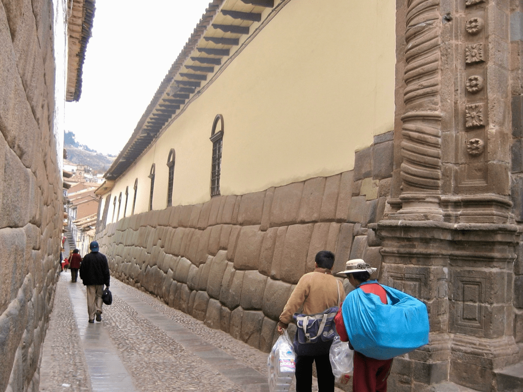
We returned to Cusco via train and van and resumed our exploration of that city. I found that its older center was a remarkable hybrid of Inca and Spanish colonial architecture: many buildings had a base, facing the street, of Inca stone walls of up to a height of some 20 ft., above which the rest of the building was whitewashed colonial (see photo above). We walked around the ancient Inca capital admiring both the Inca ruins as well as the Spanish colonial architecture. Some of streets had steep inclines and required heavy breathing in the thin Andean air (Cusco is at over 11,000 ft.).
Eventually we left Cusco and flew back to Lima. We explored that city which is mostly modern with some interspersed Inca ruins. It has a handsome waterfront but its climate leaves to be desired. It is often fogbound and drizzly. The cold Humboldt current from the south runs along the Peruvian coast creating its dreary weather conditions. Many buildings in Lima are painted in a variety of hues in an attempt to provide some color to the city. There are some handsome colonial churches but, as a whole, I found that Lima is not a particular attractive city.
2011: Argentina and Chile
This trip was probably the most extended and ambitious that we undertook in South America.
We flew to Buenos Aires, the Argentinian capital, where we stayed for a few days. We explored the city by extensive walking, visiting various neighborhoods. It is essentially a handsome city worth visiting. There are stately mansions, wide boulevards, a remarkable cemetery, parks, etc. We also went to two or three very good restaurants.
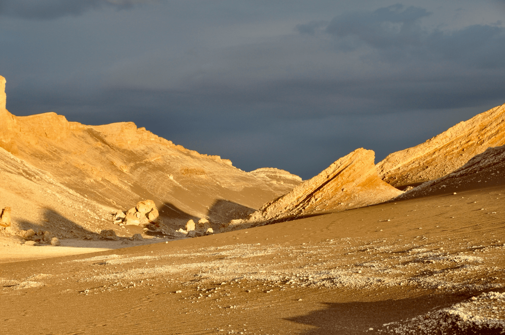
From Buenos Aires we flew south to El Calafate in the Argentinian Patagonia. We had arranged with Explora in Chile for a comprehensive voyage that would start at El Calafate and take us, via El Chaltén, over the border to Chile to Explora in the Torres del Paine National Park from where we then proceeded to Valparaiso via Punta Arenas and Santiago. From Valparaiso, we returned to Santiago from where we flew north to Calama and ended up at Explora in San Pedro de Atacama from where, eventually we returned once more to Santiago on our way home. Altogether a very extended — three-week long — and magnificent undertaking.
I will endeavor to concentrate on highlights of this rather extended trip.
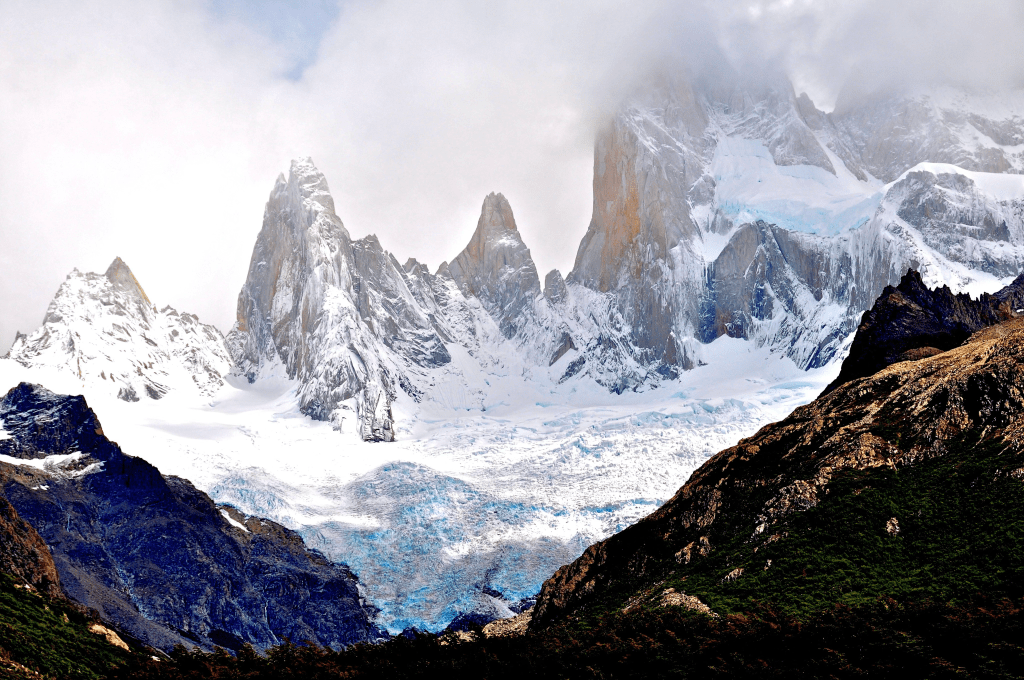
El Calafate, on the shore of Lago Argentino, is a hub town for the exploration of Argentinian Patagonia and is near the Perito Moreno glacier which we did not visit because we knew that we would see a similar glacier on the Chilean side. We were picked up from El Calafate by a van that took us north to the small town of El Chaltén located in the foothills of the spectacular Fitzroy array of peaks (see photo below).
It is worth noting that these peaks were named after Robert FitzRoy, the captain of the HMS Beagle, on which Charles Darwin travelled around the globe from 1831 to 1836.
It was on this van where we met our companions, the Heimanns, Fritz and Joanne, with whom we were to travel and hike for several days in Patagonia and who would become good friends back in New England.
Starting from El Chaltén we undertook two hikes in the company of two female guides, one, an Argentinian and the other, a Chilean from Explora.
The first hike took us to Laguna Torre which receives its water from a large glacier above. When we got to its shore, the wind was so fierce that it became very difficult to take photos as the spray kept impacting the camera lens, and standing still was nearly impossible.
The second, 7-hour, hike took us along the entire FitzRoy massive with magnificent views of the towers, glacial lakes and glaciers above.
We departed after having been in El Chaltén for four days. We were then driven southward by our Argentinian driver over extensive flatlands east of the Andes. Eventually, on a small westward road we stopped at the Argentina/Chile border station where vans and drivers were exchanged. We then continued until we reached Explora Salto Chico in the midst of the Torres del Paine park.
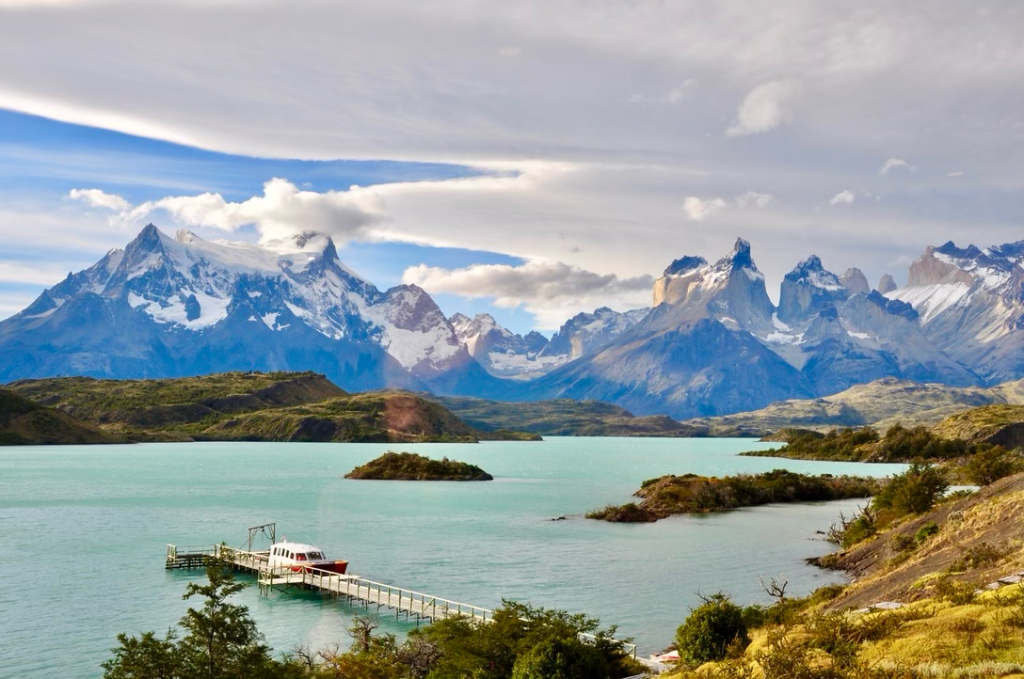
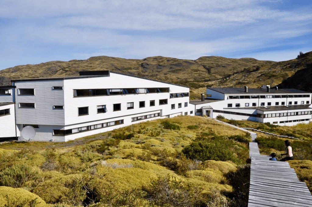
We had been at this Explora lodge before, as I mentioned previously, under Chile 1996. It is a stunning place with an equally stunning view of beautiful glacial lakes with the spectacular backdrop of the Cuernos del Paine peaks, so often pictured in travel brochures (see above, view from our room window). Below, the lodge and its dinning room.
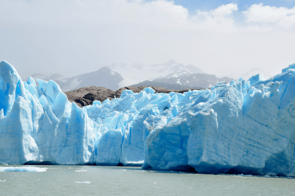
We stayed at this Explora lodge for 5 days during which we took several guided hikes. The most memorable was one we had taken, in part, during our previous 1996 visit, above the shore of Grey Lake, reaching near one of the southern terminal tongues of the gigantic Campo de Hielo Sur, the largest land glacier after those of the Antarctic and Greenland. At that end of the hike, we were picked up by a small ferryboat that took us to the edge of the glacier (see photo below).
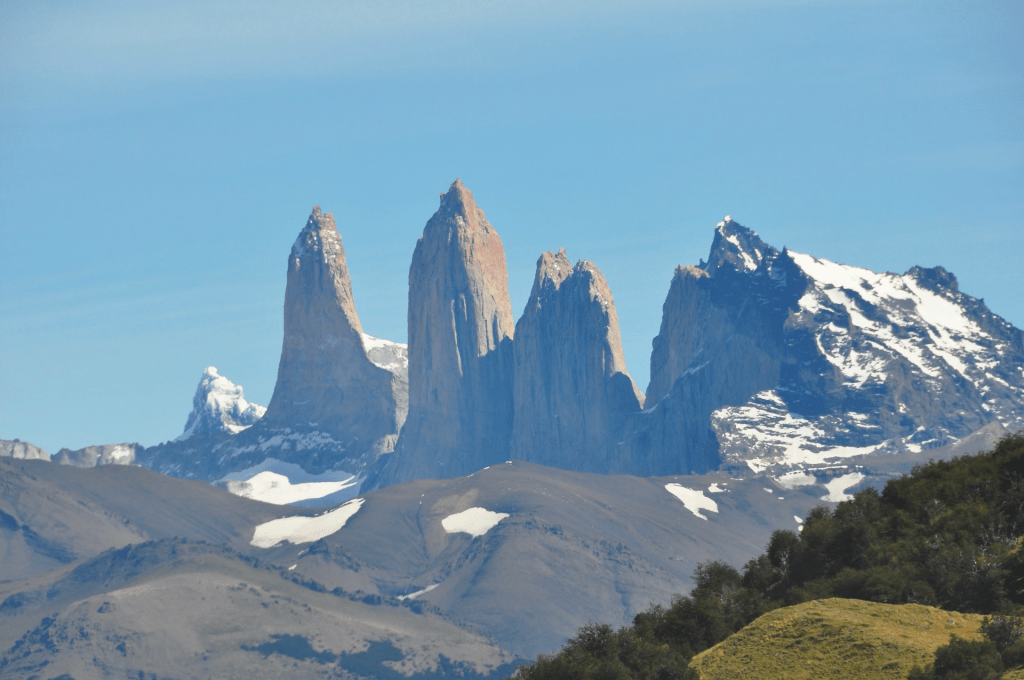
On another hike we were able to sight the impressive iconic towers called Torres del Paine (see upper photo above).
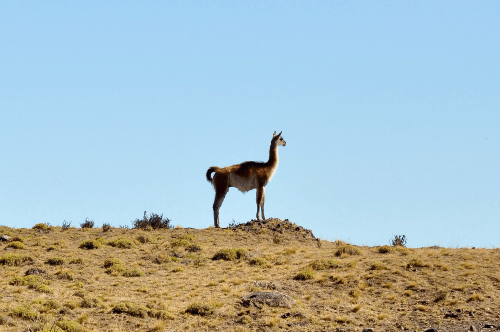
The most pervasive fauna we sighted on some of our hikes were the
stately guanacos, camelids that are characteristic of that region (see photo below).
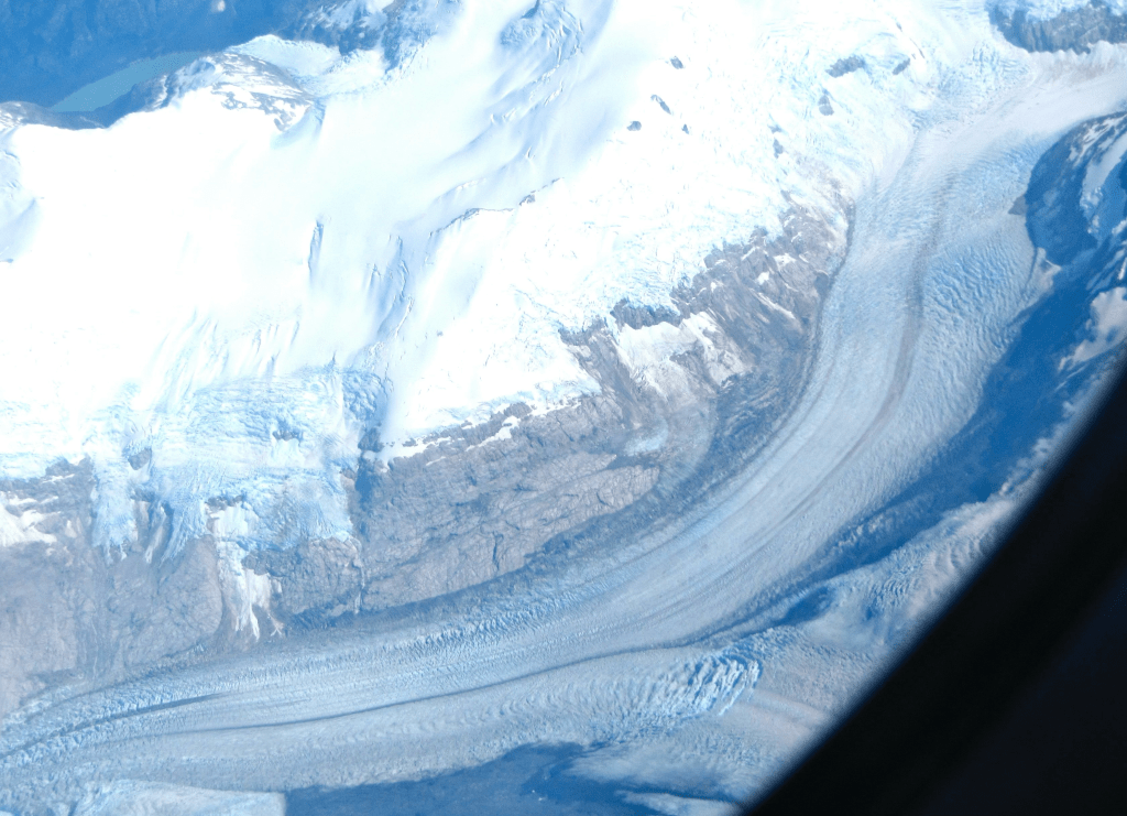
At the end of our stay at this southern Explora lodge we were driven to Punta Arenas, on the strait of Magellan, from where our flight back to Santiago departed. This flight took us northward over the Campo de Hielo Sur (Southern Ice Field) which I had mentioned above. It provided me with the opportunity to take numerous pictures, through the airplane window, of this stupendous ice mass, its countless enormous glaciers flowing in all directions, hanging lakes, and protruding mountain peaks. This ice field extends some 220 miles paralleling the Andes chain of mountains. That flight from Punta Arenas to Santiago was thus truly remarkable. Below is one of 61 photos I was able to take of the ice field, during 40 minutes, while the plane was on its course at an altitude of over 30,000 ft.
Once more we landed in Santiago, the inevitable hub when traveling in Chile. We were picked up on arrival at the airport and driven to Valparaíso, the main port of Chile, about a 90-minute drive from the capital.
We stayed in Valparaíso for two nights and had a chance to explore this interesting city with a local guide supplied by Explora. It is located at two distinct levels, one lower one adjacent to the coast and the other on a hill above. There is a funicular that, conveniently, provides transport between those two levels. During this 2011 visit I clearly remembered my previous visit in 1942 during my family’s momentous wartime trip from Spain to Ecuador. I was then 8 years old, when we stayed for a couple weeks at the upper level of the city awaiting our seaborne continuation up the western coast of South America.
Again, we were driven to Santiago’s airport from where we flew north to Calama in the Atacama region of Chile. In Santiago we were joined by Marcela Vial, the wife of our representative Carlos Vial, a vivacious, personable and intelligent Chilean with distinctly mestizo facial traits, as contrasted with her blond equally Chilean husband.
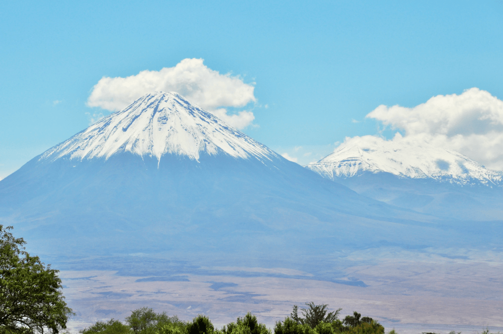
From Calama we were driven to San Pedro de Atacama where the northern Explora lodge is situated, another strikingly modern hotel, in view of the beautiful conical (19,400 ft) Licancabur stratovolcano (see photo below) which contains at its crater one of highest lakes in the world. No recent eruptions have been recorded.
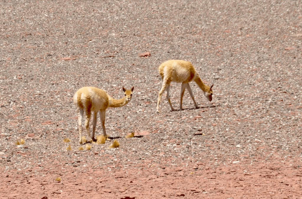
We were taken on several excursions and hikes from Explora. The surrounding countryside often resembles the Martian environment (see photo above). On one of these excursions, near a salt flat area we sighted a pair of wild vicuñas (see photo below).
After five days in Atacama we returned to Santiago, again via Calama and stayed for a few days at the Vials’s strikingly modern house, before returning home. A truly memorable voyage through South America’s south.
We came to the conclusion that Chile is one of the most spectacular and rewarding countries to visit, not surprising as it extends some 400 of latitude from its northern border with Perú to its southern tip at Cape Horn, wedged between the Pacific Ocean and the Andes cordillera.
2018: Ecuador
The last trip we undertook to South America was concentrated on Ecuador, my adopted land. The main purpose of that voyage was to acquaint my family with the country in which I grew up and had given us a safe haven from persecution in Europe during WWII.
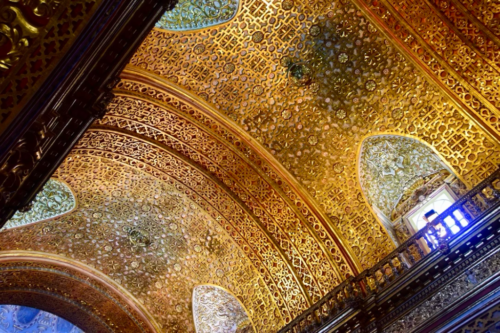
The traveling family consisted, initially, of my two sons, Claudio and Armin, their wives, Nina and Chrissy, Claudio’s son , Nina’s son Hamilton, my wife Evelyn and I. We started in Quito, that had been my abode for 16 formative years. We stayed at luxurious hotel Gangotena on the iconic Plaza de San Francisco adjacent to the eponymous church and monastery (see upper photo below), one of the high points of Spanish colonial architecture of the city. We explored the center of Quito with visits to the church of San Francisco and the nearby church of La Compañía, the latter, a true jewel of Spanish colonial interior baroque/mudéjar gold (see lower photo below ).
We had a celebratory dinner for my dear friend Gustavo Fierro and his wife, Fanny, at our hotel. We also organized an afternoon gathering there for several of my Quiteño friends, including Ovidio and Betty Wappenstein, Gonzalo and Nicolás Dousdebés and his wife, an emotional reunion where I was to see the former three for the last time before their passing.

We took an excursion to the equator line, a dozen miles north of Quito.
We (the eight of our family) took the cablecar to the Cruz Loma breathtaking view point at 4,100 m (13,400 ft), above Quito. I had ascended to that point twice in the 1950s on the way to the 4,700 m (15,400 ft) summit of Rucu Pichincha. There was no cablecar at that earlier time.
After three days in Quito, we were driven to hacienda Zuleta, north of the capital. Evelyn and I had stayed there in 2007, as I described previously.
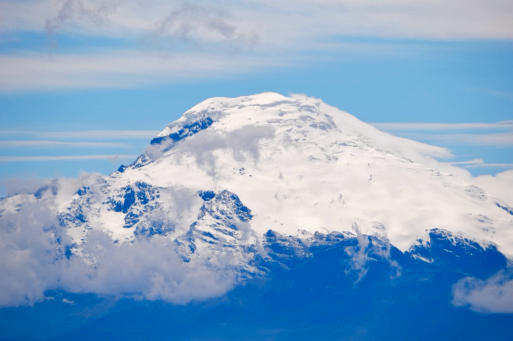
Again we took some hikes there in view of the Cayambe volcano (5,790 m, 19,000 ft) (see photo above) that straddles the equator line, and visited the market at Otavalo where the family purchased several woven items.
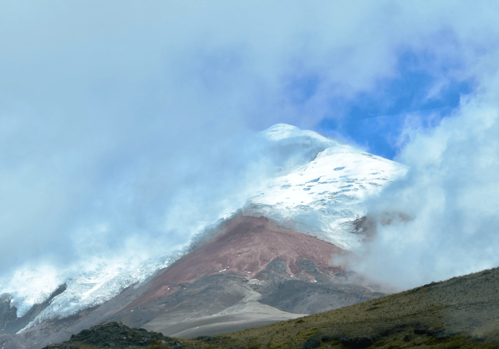
We undertook two excursions from San Agustín. The first took us to the slope of the Cotopaxi volcano, similarly to what Evelyn and I had done before. However, this time, Claudio, Armin, the guide and I managed to ascend on foot up to the hiker’s refuge at an altitude of 16,000 ft, under the edge of the upper glacier. We had a cup of hot chocolate there to fend off a cold and raw wind (photo of Cotopaxi below with red-roofed refuge visible at lower center).
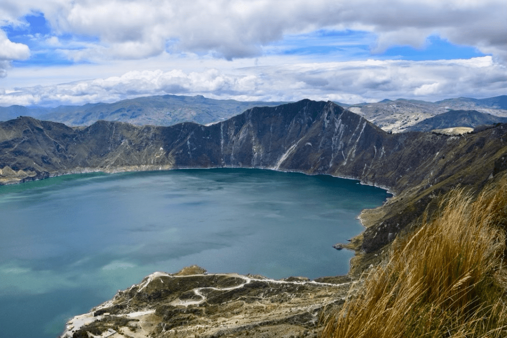
The second excursion from San Agustín was to lake Quilotoa, a remarkable caldera reminiscent of Crater Lake in Oregon. The surface of the lake is at 11,500 ft and the edge, along which there is a hiking trail, reaches 12,800 ft. It is rather spectacular and worth visiting (see photo below).
After the first day at Zuleta, two of our family group, my grandson and Hamilton,
had returned home in the U.S.
Following San Agustín, the six of us, were driven to Quito’s airport from where we flew, with a small airplane, to the port of Francisco de Orellana, also called Coca, on the Napo river, a major tributary of the Amazon, on the east side of the Andes. From that river port we were picked up by a motorized boat that took us downstream, about 40 miles, to the Sacha ecolodge on the banks of the Napo, a wide and impressive river section that already portended its final extent at its confluence with the mighty Amazon.
We spend three days in Sacha during which we took a jungle canopy walk along an extended, 1,000-foot long, 100-foot high walkway, unfortunately marred by rainy weather. We were also taken to an indigenous settlement.
Sacha is a well appointed lodge with good food an pleasant accommodations.
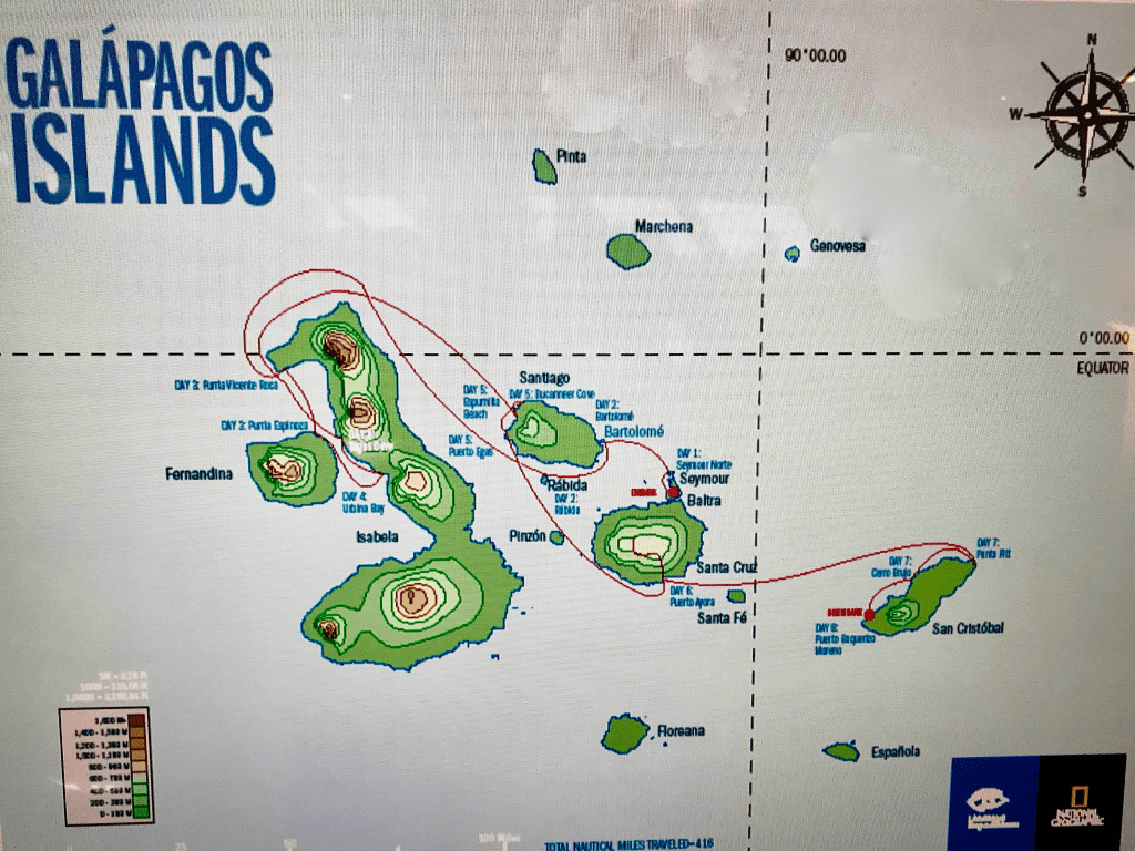
We returned to Quito via Coca and the younger family members then flew back to the U.S. leaving Evelyn and I to continue our travel. After spending the night in Quito, the two of us flew to the Galápagos islands, 35 years after our first visit there, as described previously. This time, we embarked on the National Geographic Islander 48-passenger cruise ship operated jointly with Lindblad Expeditions.
This second Galápagos cruise was more extended than our first one in 1983 — seven rather than four days — and included visits to the most western islands which we had not seen previously: Isabela and Fernandina, the former being, by far, the largest of the archipelago, with six volcanic craters. Their English names had been Albermarle and Narborough, respectively.
Here is the pertinent introductory Wikipedia paragraph:
“The Galápagos Islands (Spanish: Islas Galápagos) are an archipelago of volcanic islands in the Eastern Pacific, located around the equator, 900 km (560 mi) west of the mainland of South America… with a population of slightly over 33,000 (2020). The Galápagos are famous for their large number of endemic species, which were studied by Charles Darwin in the 1830s and inspired his theory of evolution by means of natural selection. All of these islands are protected as part of Ecuador’s Galápagos National Park and Marine Reserve”.
The map below depicts our cruise itinerary, starting at the small island of Baltra where there is an airfield that had been constructed by the U.S. Navy during WWII and where we boarded our ship.
As I had mentioned before, one of the most unusual and striking characteristic of the Galápagos islands is the behavior of its fauna. As there is no evidence of human presence there before its accidental discovery by Bishop Tomás de Berlanga in 1535, the animals are not afraid of approaching people, in fact, it is demanded by the local authorities to keep a prudent and protective distance from the animals. On the island of Fernandina, we had to avoid stepping inadvertently on marina iguanas which congregated by the thousands on the ocean shore and were rendered almost invisible by their dark coloring against the similarly dark volcanic rocks on which they were sunbathing.
As is customary on these Galápagos cruises, we frequently disembarked on various islands by transferring from ship to shore on inflatable boats, called zodiacs, on which we were always expected to wear lifejackets. We were also taken by zodiacs near and around various islands to observe and photograph shorebirds and other animals.
The variety of fauna on and around these islands is rather striking and often unique to them such as the marine iguanas, clearly differentiated from the land iguanas we sighted. There were the Galápagos penguins, for example, only found on these islands and are the northernmost birds of that genus in South America.
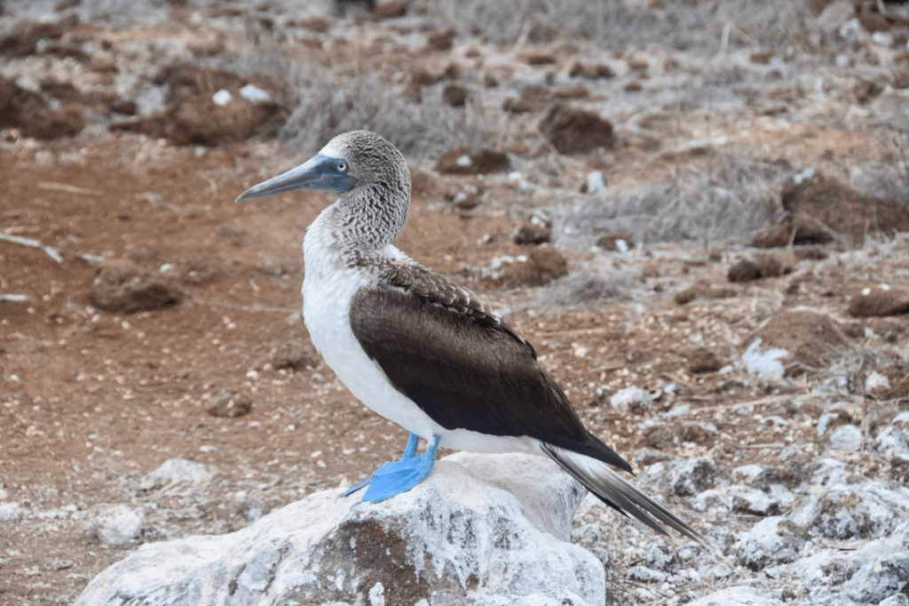
We encountered several of the iconic giant tortoises from whom the islands derived their Spanish name, and we were treated to spectacular sightings of blue whales, the largest animal known ever to have existed, which can reach a length of about 100 ft. I can’t avoid including a photo of the stately and equally iconic blue-footed booby (see below).
The food on board of our cruise ship was excellent, and the crew and guides, were pleasant and engaging. We flew back from the island of San Cristóbal to the Ecuadorian port of Guayaquil where we spent one night and had dinner with several of my erstwhile Politécnica classmates. The next morning we were picked up by my classmate Gustavo Larrea and we drove north to the coastal resort town of Olón where he owned a lodge on a nearby hill. We stayed there for two days, with several of the classmates that had not joined us in Guayaquil. We hiked and explored the nearby area through coffee plantations.
We were then driven back to Guayaquil from where we flew back home.
Evelyn and I had thus visited, during this remarkably varied trip, all four regions of Ecuador: the Andean altiplano, the Amazonian region, the Galápagos islands and the coastal region.
Coda: With the above described visit to Ecuador in 2018, we were able to avoid the subsequent regrettable descent of that beautiful, and until then uniquely peaceful, country into the chaos and instability of the last few years, as I am writing these lines in 2025. I can only hope for a prompt return to normalcy there as I have a deep affection for that country and its people which received us with open arms, back in 1942, when nearly any other destinations, including the U.S., had been barred to my family and I.
